Ptolemy: Picture courtesy of Almagest Ephemeris Calculator
Ptolemy:
Picture courtesy of
Almagest Ephemeris
Calculator
Karen Franco
kffranco(at)interchange(dot)ubc(dot)ca
Student # 46347985
MATH 308, Section 102
Final Project
December 15, 2002
Table of Contents:
I.
Introduction
II.
The Basics of Spherical Geometry
III.
Great Circles
IV.
Spherical Triangles
A Tale of Two Cities: The Cross-Continental Application of the Solution of
Spherical Triangles
V.
Conclusion
References
I. Introduction
Captain Cook, mathematician? It is a little known fact that Captain James Cook,
discoverer of Australia, New Zealand, Papua New Guinea, Hawaii, Tahiti and other
islands in the Pacific, was trained as both a navigator and as a mathematician.
In fact, mathematics and exploration have a long history dating back to the
times of the Greek and Phoenician mariners.
In the modern world, mathematics is commonly regarded as a "sit-down" science --
a subject where problems are often solved while sitting down in a classroom or
office, and applications often relate to theory, finance, or business. However,
during the days of exploration, when it was discovered that the world was indeed
round and not flat, spherical geometry was integral in mapping out
the world, in navigating the seven seas, and in using the position of stars to
chart courses from one continent to another.
Spherical geometry is defined as "the study of figures on the
surface of a sphere" (MathWorld), and is the three-dimensional, spherical
analogue of Euclidean or planar geometry. On a sphere, two lines can be
parallel and still intersect each other not once but twice, the sum of
the angles of a triangle is greater than 180°, and the shortest distance between
two points on a sphere is along the perimeter of a great circle, which is not
necessarily a straight line on a flattened map. As the Earth's shape is roughly
approximated by a sphere, these properties of spherical geometry aided explorers
in charting out the globe and astronomers in plotting the course of planets and
stars. Present day applications of these same properties include planning
flights, cruises, and satellite orbits around the world.
II. The Basics of Spherical Geometry
A sphere is defined as a closed surface in 3D formed by a set of points an equal
distance R from the centre of the sphere, O. The sphere's radius
is the distance from the centre of the sphere to the sphere's surface, so based
on the definition given above, the radius of the sphere = R.
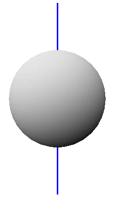 An arbitrary straight line (not lying in the sphere) and sphere in three
dimensional space can either (a) not intersect at all; (b) intersect at one
point on the sphere, when the line is tangent to the sphere at the
point of intersection; or (c) intersect at precisely two points, when the line
passes through the sphere. In this particular case, if the line passes through
the centre of the sphere and intersects the sphere's surface in two points, the
points of intersection form the antipodes of the sphere. The
North and South Poles (both the magnetic and geographic poles) are examples of
antipodes on the globe.
An arbitrary straight line (not lying in the sphere) and sphere in three
dimensional space can either (a) not intersect at all; (b) intersect at one
point on the sphere, when the line is tangent to the sphere at the
point of intersection; or (c) intersect at precisely two points, when the line
passes through the sphere. In this particular case, if the line passes through
the centre of the sphere and intersects the sphere's surface in two points, the
points of intersection form the antipodes of the sphere. The
North and South Poles (both the magnetic and geographic poles) are examples of
antipodes on the globe.
Figure 1: Line passing through the centre of the sphere; points of intersection are antipodes (PostScript file)
III. Great Circles
Like lines and spheres, an arbitrary straight plane and sphere in three
dimensional space can have (a) no intersection; (b) one point of intersection,
when the plane is tangent to the sphere at that point; or (c) an
infinite number of points of intersection, when the plane cuts through the
sphere and forms a circle of intersection.
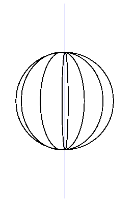
Figure 2: The meridians of longitude are examples of great circles (animated PostScript)
Great circles are defined as those circles of intersection which share the same radius R and same centre O as the sphere it intersects. As their name implies, the great circles are the largest circles of intersection one can obtain by passing a straight plane through a sphere. On the globe, a line or meridian of longitude forms half of a great circle running from pole to pole and with its centre at the centre of the Earth. Another example of a great circle on the globe is the Equator, found at 0° latitude.
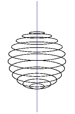
Figure 3: The parallels of latitude are examples of small circles (animated PostScript)
Imagine a line from the North to the South Pole, passing through the centre of
the globe. The circles of intersection formed by the globe and a plane
perpendicular to this imaginary line make up the globe's lines or parallels of
latitude. Each of these circles of intersection, with the exception of the
Equator at which point the plane is at the midpoint of the pole-to-pole line,
are called small circles precisely because their radii measure
less than the Earth's radius R.
Navigators often used great circles to figure out the most efficient route to
their destinations. It turns out that the shortest path between two points on a
sphere is along a great circle path, that is, along an arc of a great circle.
Have you ever wondered why a plane flying from Vancouver to the Philippines
follows a route that takes you over Japan and Korea instead of flying a straight
line over the Pacific Ocean? Or why a flight from New York to Europe has to
travel over the Maritimes and almost reach Greenland instead of making a beeline
over the Atlantic Ocean? The exact reason behind the logic of taking great
circle paths to travel the world is explained and proved in the following
section.
IV. Spherical Triangles
When the arcs of three great circles intersect on the surface of a sphere, the
lines enclose an area known as a spherical triangle. Angles
between great circles are measured by calculating the angle between the planes
on which the great circles themselves lie. How is this possible? The spherical
angle formed by two intersecting arcs of great circles is equal to the angle
between the tangent lines formed when the great circle planes touch the circle
at their common point (an antipode of the sphere since two great circles
intersect each other in a line passing through the sphere's centre).
Have you ever heard of a triangle whose angles sum up to greater than 180°? In
the figure below, the two meridians of longitude are separated by an angle of 90°
and both lines of longitude fall perpendicular to the Equator (the only great
circle of latitude). Each angle in this particular spherical triangle equals
90°, and the sum of all three add up to 270°.
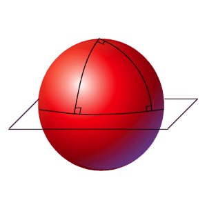
Figure 4: In this triangle, the sum of the three angles exceeds 180° (and equals 270°)
Spheres have positive curvature (the surface curves outwards from the centre),
hence the sum of the three angles of a triangle exceeds 180°. On a plane with
zero curvature, the sum of a triangles angles equals exactly 180°.
Like their angles, the length of the sides of a spherical triangle are measured
in degrees or radians. Specifically, the length of a side of a spherical
triangle equals the measurement of its opposite angle. In geography, the angle
between two meridians of longitude equals the same number of degrees as the arc
cut off by these lines of longitude on any circle of latitude. So, in the above
figure, each of the sides measures 90° since each of their opposing angles
measures 90°.
The most useful application of spherical triangles and great circles is perhaps
calculating the shortest-distance route between two points on the globe. This
application is often referred to as the solution of spherical triangles
and makes extensive use of the well known Cosine Law for triangles on a plane: c2
= a2 + b2 - 2ab cos C. Given two sides of a spherical
triangle and the angle between these sides, the solution for a spherical
triangle yields the length of the third side.
Figure 5: The solution of a
sphere
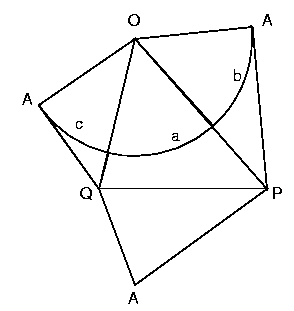
Figure 6: The net of the tetrahedron used for the solution of a spherical triangle (animated PostScript)
Therefore the formula for the third side, a, of a spherical triangle, given two sides, b and c, and their included angle, A is
cos a = cos b · cos c + sin b · sin c · cos A
A Tale of Two Cities: The Cross-Continental Application of the Solution of
Spherical Triangles
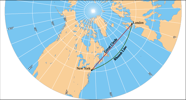
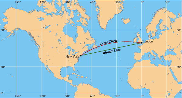
Figure 7: Pictures courtesy of Maps.com
Imagine you had to find the best route from New York to London. New York is geographically located at along the great circle of longitude 74° 0' W and approximately 40° 42' latitude north of the Equator, which makes it 90° - 40° 42' = 49° 18' south of the North Pole. London, on the other hand, is located along the great circle of longitude 0° 5' W at approximately 51° 32' north of the Equator, which makes it 90° - 51° 32' = 38° 28' south of the North Pole. The sides b and c are given by the length of the arcs from the North Pole to New York and London respectively, so b = 49° 18' and c = 38° 28'. The angle A is given by the difference in meridians of longitude for the two cities: A = 74° 0' W - 0° 5' W = 73° 55'.
Applying the solution cos a = cos b · cos c + sin b · sin c · cos A, we get the following calculation:
cos a = cos 49° 18' · cos 38° 28' + sin 49° 18' · sin 38° 28' · cos 73° 55'
cos a = (0.6521 · 0.7830) + (0.7581 · 0.6221 · 0.2770)
cos a = 0.6412
a = 50.1186° or 50° 7'
This means that the great
circle distance between New York and London is approximately 50° 7'. In miles,
given that one degree of a great circle is approximately 69 miles (110.4
kilometres), this distance measures approximately 50.1151° x 69 miles = 3458
miles (5533.0934 kilometres).
V. Conclusion
Geometry derives its meaning from the Greek words geometria and
geometrein which mean "measuring the earth". Geography, on the other hand
derives its meaning from the Greek words geographia and geographein
which mean "describing or writing about the earth". One would expect words so
similar in meaning to be similar in concept as well. However, the two fields
were separate and distinct until the days of ancient Greece, when Ptolemy
(astronomer, mathematician and geographer) made use of geometry in reasoning
more about the earth and its shape:
"In Geography one must contemplate the extent of the entire earth, as well as its shape, and its position under the heavens, in order that one may rightly state what are the peculiarities and proportions of the part with which one is dealing... It is the great and exquisite accomplishment of mathematics to show all these things to human intelligence..."
Interestingly enough, it was
also Ptolemy and not Christopher Columbus who discovered that the earth was
spherical and not flat, and stated his rationale in the Almagest 1300
years before Columbus sailed around the world:
"If the earth were flat from east to west, the stars would rise as soon for westerners as for orientals, which is false. Also, if the earth were flat from north to south and vice versa, the stars which were always visible to anyone would continue to be so wherever he went, which is false. But it seems flat to human sight because it is so extensive."
Like geometry and geography, the worlds of spherical geometry (used in
geography) and planar geometry (commonly taught in most geometry courses) are
closely related and yet extremely different.
Anybody who has completed high school level geometry (or to some extent,
elementary geometry) knows that in Euclidean or planar geometry, two parallel
lines never meet, the sum of the three angles of a triangle add up to 180°, and
the shortest route to get from one point to another is a straight line. In the
world of spherical geometry, two parallel lines on great circles intersect
twice, the sum of the three angles of a triangle on the sphere's surface exceed
180° due to positive curvature, and the shortest route to get from one point to
another is not a straight line on a map but a line that follows the minor arc of
a great circle. Maps provide a way of translating the spherical view of the
world to a planar view, by projecting the Earth's topologies and locations to a
flattened surface using Hammer, Mercator or cylindrical methods. A consistent
and standard representation that minimizes projective distortions is yet to be
established.
The discovery of spherical geometry not only changed the history and the face of
mathematics and Euclid's geometry, but also changed the way humans viewed and
charted the world. Using this new knowledge, explorers and astronomers used the
circular path of stars to navigate the earth to discover new lands and reason
about the cosmos.
References:
Borowski, E.J. and Borwein,
J.M. Collins Reference Dictionary of Mathematics. 1989: Collins.
London and Glasgow.
Casselman, Dr. W. A Manual of Mathematical Illustration. [MATH
308 text]
Hogben, Lancelot. Mathematics for the Million. 1951: W.W. Norton and
Company, Inc. New York.
Hogben, Lancelot. Science for the Citizen. 1950: W.W. Norton and
Company, Inc. New York.
Maps.com - Learn and Play. Map Skills: Great Circles. [Maps.com web page]
Mariners' Museum, The. The Mariners' Museum -- Newport News, Virginia.
[background image for web
page, historical background]
Osserman, Robert. Poetry of the Universe: A Mathematical Exploration of the
Cosmos. 1995: Anchor Books, Doubleday. New York.
Polking, John C. The Geometry of the Sphere 1. [basic
information about spheres]
WhatIs?Com. Latitude and Longitude: a WhatIs Definition. [what
is latitude and longitude?]
Wolfram Research, Inc. MathWorld: Eric Weisstein's World of Mathematics.
[MathWorld web
page]
TROUBLESHOOTING:
In order to run any of the PostScript files, you need a free PostScript interpreter installed on your computer: GhostView and GhostScript are the most popular ones. Click on the links to obtain these.
For latitude.ps and
longitude.ps, make sure you have ps3d.inc in the same directory as these files
(see KarenFrancoProject.zip file if this is missing).