|
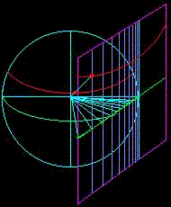
For the equatorial case of the Gnomonic projection, the source of light
is situated at the centre of the globe, like in all other gnomonic projections.
But, unlike that of the polar case, the plane of projection (dark purple
in Figure A) touches the globe at the equator (green line). When projected,
all great circles are again represented as straight lines in the projection
plane. This is depicted in Figure A where the green line on the plane
is the projected equator and the light purple lines represent straight
and parallel meridians. Unlike the equator, other parallels are curves
conves to the equator. Note the red line on the projection plane in Figure
A is where the projected parallel intersects with the particular light
puple meridian.
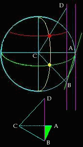
Refering to Figure B, the mathematical calculations for the intersections
of parallels with the meridians can be logically deduced. With the equator
running from AB and touching the earth tangentially at point A, the central
meridian becomes projected at the same point from the light ray AC. Because
the light ray goes through the centre and touches the tangential point,
it satisfies both conditions which leads to a perpendicular intersection
with the equator. As such, <CAB = 90°. Therefore, triangle ACB
becomes a right angle triangle. Another right angle triangle exist because
of the fact that all meridians are perpendicular to the equator. As a
result, all light rays that produces the projection of the equator is
also perpendicular to the meridians. This is the case with the light ray
BC with meridian DB, therefore, <CBD = 90°. The distance of the
projected parallel away from the equator would be DB. DB's distance could
be calculated using the two triangles DCB and ABC. Given that AC is the
radius of the circle and <ACB is the angular distance of the longitude,
BC = circle's radius * sec (angular distance of longitude) since cos (angular
distance of longitude) = CA / BC. With <DCB equal to the angular distance
of the latitude and <CBD = 90°, the length of DB = tan (angular
distance of latitude) * circle's radius * sec (angular distance of longitude).
This is because tan (<DCB or latitude) = DB / BC.
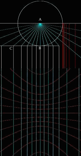
It is clear from Figure C that the meridians are constructed by extending
light rays at the desired rotation away from the central meridian (or
the line that touches the tangential point). The intersections of such
rays with the equator (or the horizontal line tangential from the circle)
will be equivalent to the distance away from each other. The relationship
of these distances will be the circle's radius * tan (angular distance
of longitude). This fact can be proven using the triangle AOB in Figure
C. With <BOA equal to the angular distance of longitude and OA equal
to the radius of the circle, the desired distance AB is equal to circle's
radius * tan (angular distance of longitude) since tan (<BOA) = AB/OA.
As such the map in Figure C is produced.
|