|

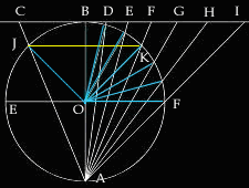
Stereographic projections are created by projecting from a point at one
end of the diameter in a circle to a projection plane which sit tangential
to the other end of the diameter. This situation is clearly depicted in
Figure A where the light source comes from point A with white rays radiating
out of it. Geometrically, the light source sits on the bottom end of diameter
AB. In terms of geography, the light source sits on the south pole of
the earth with the projection plane CI on the north pole, thus making
the projections on this plane a polar projection. Visually, one can think
of the stereographic projection as being created by the shadows casted
upon the projection plane CI by the parallels and meridians.
With the yellow lines representing parallels and the angle the blue lines
makes withe the equator representing angular distance away from the equator
EF, shadows of parallels are located at the intersection of the light
rays with the plane of projection such as C, B, D, E, F, G, H, and I.
As noted in the picture, these rays all goes through the same intersection
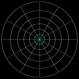
point made by the parallel with the circle. When looking upon this plane,
latitudes will appear as circles whose radius is equal to the distance
the polar axis AB is away from such intersections as C, B, D, E, F, G,
H, and I as illustrated in Figure B. Mathematically, this distance can
be calculated using circle geometry. Referring to Figure A, if an arbitrary
latitude JK is chosen, its angular distance is <EOJ. Because the polar
axis and the equator are perpendicular to each other, <EOJ and <BOJ
are complementary angles. As such <BOJ is also known as a co-latitude.
In other words, <BOJ = 90° - <EOJ. A similar situation occurs
on the supplementary side of the latitude. Thus, <FOK=angular distance
of latitude and <KOB = co-latitude. Therefore, <KOB=<BOJ and
<EOJ=<FOK. Utilizing a fact from circle geometry, there is a central
angle <JOK subtended by the arc JK. Since <JAK is also subtended
by the same arc JK, but touching the side of the circle, the relationship
between <JOK and <JAK is as follows: <JAK= 1/2 <JOK. Because
JK is perpendicular to the polar axis BA which goes through the center
of the circle, BA bisects JK and similarly <JOK and <JAK. This is
because <JAK and <JOK are opposite angles to the bisected latitude.
The relationship <JAK = 1/2 <JOK becomes <JAB+<KAB=1/2 (<JOB+<KOB).
Since <KAB = <JAB and <JOB = <KOB, 2 <JAB = 1/2 (2 <JOB)
therefore <JAB=1/2<JOB. With AB equivalent to the diameter of the
earth or 2 radius and the plane CI tangential to the circle, therefore,
<CBO is a right angle. Thus the following relationship can be formed:
tan (<JAB) = JB (radius of the latitude) / circle's diameter. In other
words, radius of the latitude = 2 circle's radius * tan(1/2<JOB). In
conclusion, radius of latitude = radii * tan(co-latitude). Since tangent
reaches infinity at 90°, the polar stereographic projection cannot
reveal an entire hemisphere. Another interesting fact about the stereographic
polar projection is that smaller latitudes are farther away from the center
point of the projection (which represents the north pole) at the point
where the polar axis intersects the projection plane.
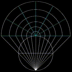
By visually imagining the meridians from a birds eye view, one can imagine
that the meridians, which is the semi circle following the shape of the
earth from the poles, will be projected as the straight radius of the
outer most latitude as seen in Figure C. These equally spaced radius are
rotated around the center with the desired angular interval. Therefore,
the number of meridians with angular distance n° apart from each other
would have 360°/n° number of meridians.
|