|

In Orthographic projections, projections of parallels and meridians are
created by projecting from a point at infinite distance away from the
projection plane, which sit tangential to the other end of the diameter.
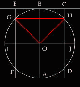
This situation is clearly depicted in Figure A where the light source
comes from the south of the circle at an infinite distance. As a result,
the white rays radiating from that infinite point willl appear to go through
the earth parallel to each other (as is the case of AB, CD and EF). The
projection plane CE is situated tangentially to the north of the polar
axis AB. Such an arrangement makes this projection a polar projection.
Like other Zenithal projections, one can think of the orthographic projection
as being created by the shadows casted upon the projection plane CE by
the parallels and meridians.
With the red line segment GH representing an arbitrary parallel and
<GOI & <HOJ equal to the angular distance away from the equator,
shadows of parallels are located at the intersection of the light rays
with the plane of projection such as C, B, and E. As noted in the picture,
these rays all goes through the same intersection point made by the parallel
with the circle. When looking upon this plane, latitudes will appear as
circles whose radius is equal to the distance the polar axis AB is away
from such intersections as C, B and E as illustrated in Figure B. Mathematically,
this distance can be calculated using circle geometry. As given in the
beginning the polar axis and the equator are perpendicular to each other,
therefore <GOI and <BOG are complementary angles. Hence, <BOG
is also known as the co-latitude of <GOI. In other words, <BOG =
90° - <GOI. Geographically speaking, all latitudes are parallel
to the equator and perpendicular to the polar axis. As such <GBO is
a right angle and <BGO = <GOI (since they are alternate interior
angles). Because BO is the diameter of the circle that is perpendicular
to GH, this implies that GK = KH. In other words, GK is the radius used
to draw the circles of the projected latitudes. By trigonometry, the following
relationship can be constructed:
- cos (<OGK) = GK/GO
- Since <OGK = <GOI = angular distance of latitude and GO is the
radius of the circle therefore GK = circle's radius * cos(angular distance
of latitude)
In conclusion, the radius of the projected latitudes is equal to the
circle's radius * cos (angular distance of the latitude). As such the
radius of smaller latitudes becomes larger and can only project up to
latitude 0 with its projected radius equal to that of the earth. This
is because the cos funtion only have values ranging from 0 to 1 for any
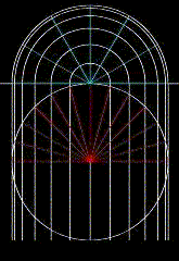
angle. The illustration in Figure C can be drawn by using the the intersection
of the polar axis with the projection plane as the centre of all circular
projected latitudes.
The meridians are drawn in a similar manner to all other meridians in
the polar case in that they become equally spaced radius rotated around
the center with the desired angular interval. Therefore, the number of
meridians with angular distance n° apart from each other would have
360°/n° number of meridians. Meridians become such straight lines
because they are in reality semi-circles following the shape of the earth
from the poles. As a result, when viewing from a birds eye view, it will
be projected as the straight radius of the outer most latitude as seen
in Figure C.
|