|

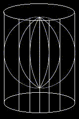
Cylindrical Projections is constructed by the projection of parallels
and meridians onto the surface of a cylinder with the earth circumscribed
within it. As a result, the surface of the cylinder is tangent to the
earth at the equator. When unfolded, the meridians will be seen as vertical,
parallel and equally spaced lines that intersect perpendicularly to the
equator (refer to Figure C). This is primarly because the cylinder touches
the equator and as such touches each of the intervals with a meridian.
Since the meridians around the earth is equally spaced and rotated around
the entire sphere, the projection will consist of equally spaced lines
for the entire map. With the cylinder being tangential to the equator,
the length of such a map would be equal to the circumference of the earth
or circle (2 * 3.1515926654... * radius). Similarly, projected parallels
are seen as straight lines that vary in distance as they move away from
the equator. The corresponding projection of the latitude CD in Figure
B is drawn from the point that the latitude intersects the circle (at
point D) through the entire map. Thus producing the map as seen below.
The distances away from the equator AB in figure B can be accurately calculated
using the relationship as deduced before: radius of the circle * sin (angular
distance of latitude). This relationship for any arbitrary latitude such
as BC in Figure B came about using the following logic. Given that latitude
AB has angular distance <AOB and that DC is parallel to AB, one knows
that the vertical distance DC is away from AB is equal to a line segment
between the two parallels and perpendicular to both. Therefore, by drawing
a perpendicular line from point D to E, this implies that <DEO is a
right angle and that sin (<DOE) = DE/OD. Because OD is equivalent to
the radius of the circle and <DOE is the angular distance of the latitude,
therefore DE = circle's radius * sin (angular distance of latitude).
Figure C
|